Meeting Location
Getting Here / Directions
Our property is located about 25 minutes southeast of the town of Utuado. The mountain roads in central PR can be narrow and winding with occasional potholes and rough sections of road. And depending on the season, you can also encounter heavy rainstorms. So with that in mind, we recommend that any overnight guests try to arrive at least a half hour before dark if possible.
Here’s the map pin to the location where we meet most of our guests. It’s located about 10 minutes from our property. From this meeting point, we’ll guide you up to the property. https://goo.gl/maps/xHxoQMBWQ1Sp5CEs5 We’ve found that visitors have the best success using Google Maps and be sure to download Google Maps “Offline Maps” for Puerto Rico so that you have directions even if you lose cell phone service. You can find the offline maps option by clicking on your profile in Google Maps and then selecting Offline Maps.
From the North Coast (San Juan, Arecibo, Aguadilla)
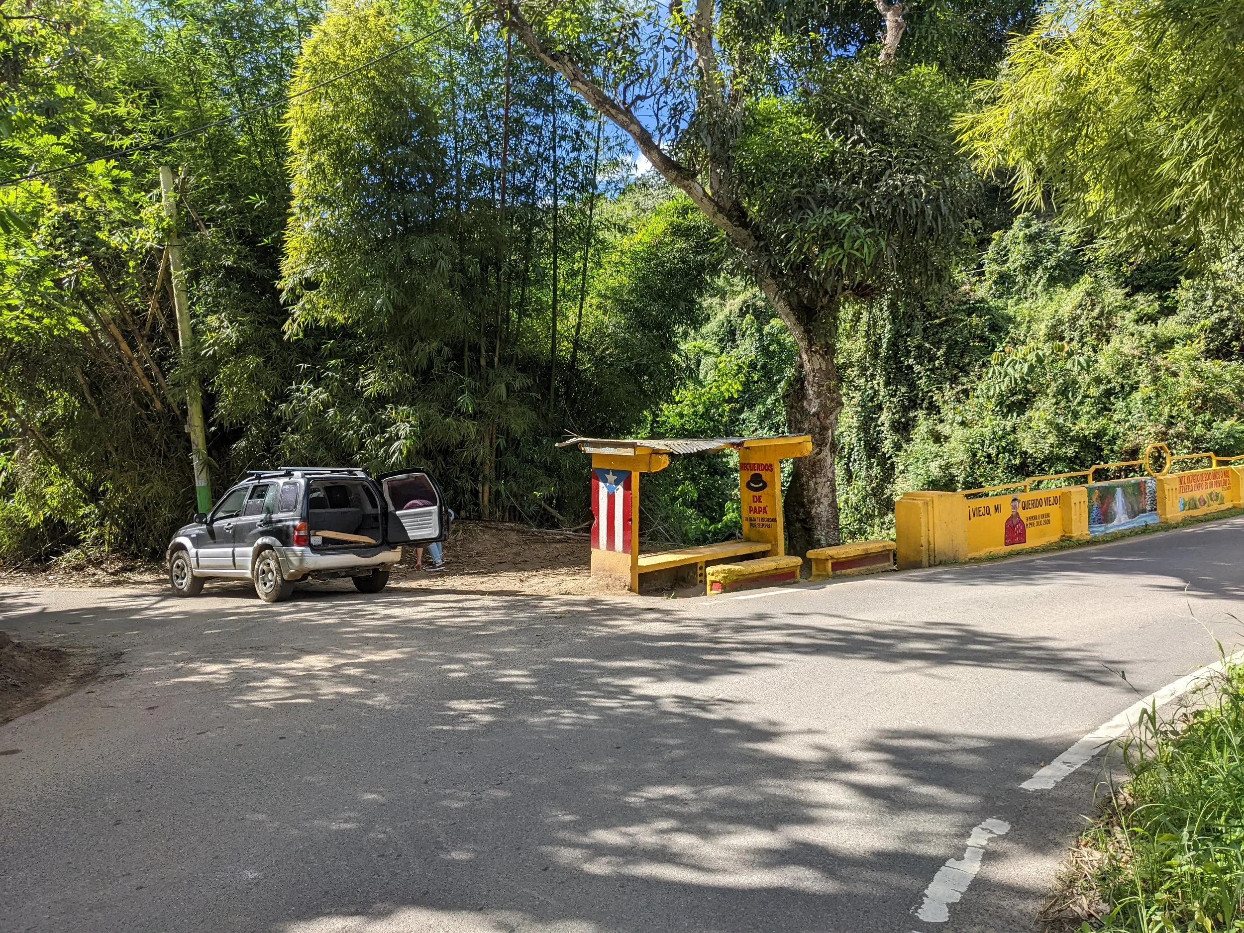
Arriving from the north is quite straight forward. Most people will turn off of the Autoexpresso at the Utuado/Adjuntas exit in Arecibo and take the Carretera/Highway 10 south to Utuado. Follow PR-111 through the outskirts of Utuado until you come to PR-605 where you’ll turn right just after the big sign that says Barrio Vivi Arriba. The road is quite narrow so be on the lookout for oncoming traffic. You’ll follow PR-605 for about 3.4 miles until you come to the meeting point which is located at a brightly colored bridge that crosses a river. Turn left just before the bridge where we’ll be waiting for you or you can park and wait for us to arrive.
From the South Coast (Ponce, Humacao, Cabo Rojo)
When arriving from the south, most people will travel through Ponce and then take Carretera/Highway 10 north towards the town of Adjuntas. You can plot your course using the map pin above, but Google Maps will usually route you on an extremely small, steep and winding road for part of the journey. So we suggest that you use two map pins to plot your journey.
Step 1: drive to map Pin #1 (30 minutes from the meeting location): https://maps.app.goo.gl/uQFtv3kZUreZw3Mq5
Step 2: once you have reached Map pin #1, then drive to Map pin #2 (Meeting location): https://goo.gl/maps/xHxoQMBWQ1Sp5CEs5
You’ll know that you’ve reached the meeting point once you get to a brightly colored bridge that crosses a river. You’ll want to right at the far side of the bridge where we will be waiting for you or where you can park and wait for us to arrive.
From the West (Rincon)
Arriving from Rincon, Aguada, Moca or Mayaguez, most people take the PR-111 through the mountain towns of San Sebastian and Lares. It’s the most direct route, but quite a winding road in many places, but quite scenic. Your other options are to take the northern route through Arecibo (many stop lights) or the southern route (a little longer drive time) but less traffic than the northern route. If taking the central mountain route, simply follow PR-111 to Utuado and then through the outskirts of Utuado until you come to PR-605 where you’ll turn right just after the big sign that says Barrio Vivi Arriba. The road is quite narrow so be on the lookout for oncoming traffic. You’ll follow PR-605 for about 3.4 miles until you come to the meeting point which is located at a brightly colored bridge that crosses a river. Turn left just before the bridge where we’ll be waiting for you or you can park and wait for us to arrive.